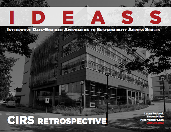
Officially opened in 2011, the Centre for Interactive Research on Sustainability (CIRS) at UBC was developed in response to the challenge of creating a more sustainable built environment. CIRS provides a case study to test decision-making frameworks and concepts, and through which further work can be undertaken in the field of sustainable design.
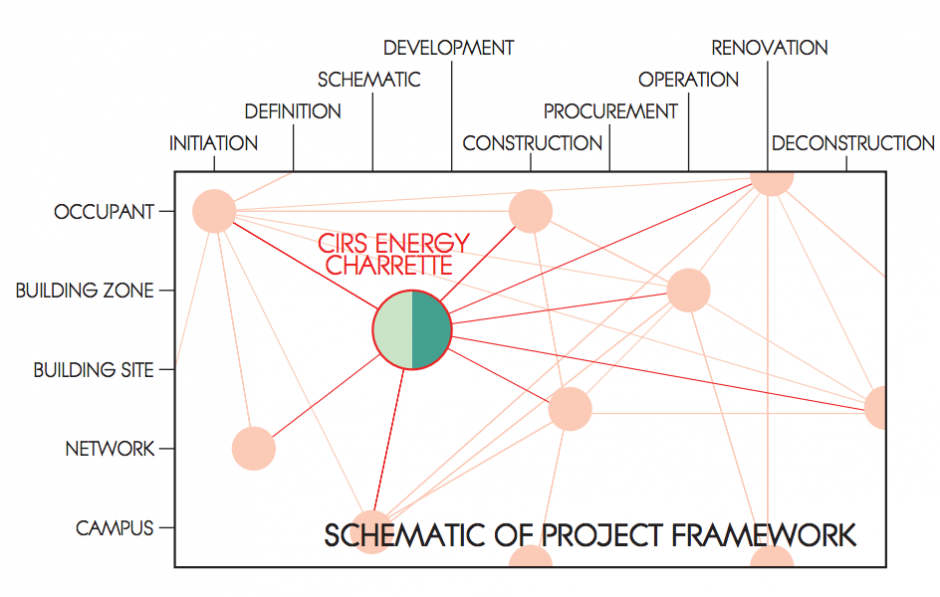
The IDEASS team completed an extensive retrospective study of CIRS that focused on the use of information in design decision-making for energy systems. The report (which can be downloaded here) describes the decision-making process that took place with regard to the energy systems design for CIRS, focusing on the period of time leading up to, including, and following the CIRS Energy Modeling Charrette (held July 4th, 2008 on UBC’s Vancouver campus).
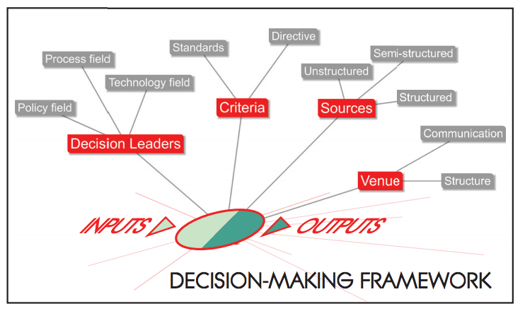
The report looks at the following decision-making factors:
• decision-making venues (where and when?)
• decision-making leaders (who was present?)
• decision-making criteria (why this decision?)
• decision-making sources (with what information?)
How the CIRS Energy Charrette was analyzed: in terms of the decision-making factors ( decision leaders, criteria, sources, and venues) as well as in terms of its inputs and outputs.
The report also includes assessments of the design process, including:
• design breakthroughs
• design challenges
• lessons for future IDEASS projects
How the CIRS Energy Charrette fits in with the other scales and design phases that will be looked at in IDEASS.
The groups in attendance at the Energy Charrette included the representatives of the architects (Busby Perkins + Will), the mechanical and electrical design consultants (Stantec, BC Hydro, BCIT, Brooks Coming, Corix, Haworth), the controls consultant (Honeywell), and The University of British Columbia (Academic, Properties
Trust, Plant Operations, Sustainability Office, Utilities, Office of the AVP, and Campus and Community Planning).
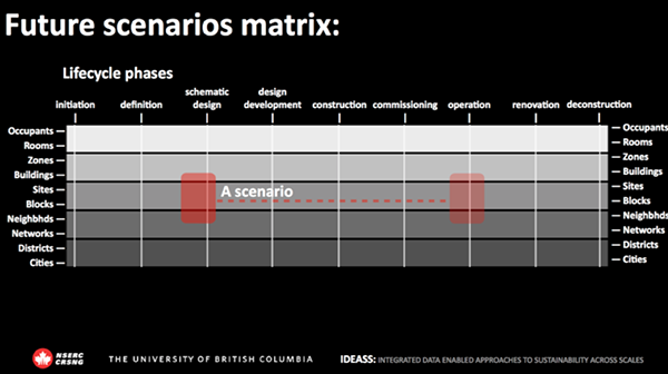
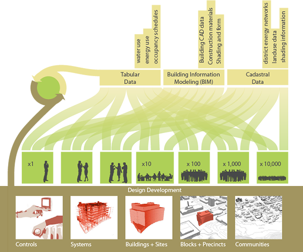
IDEASS has developed a matrix, pictured here, for defining the problem space of future scenarios of data integration in the lifecycle of the built environment.
The vertical axis articulates the scales at which the built environment is created (from the human scale of rooms at the top to the urban scale of cities at the bottom).
The horizontal axis represents a built environment lifecycle from planning and design to construction to decommissioning (from project initiation at the left to deconstruction at the right).
Within the matrix, users can define potential scenarios of data-enriched planning and design processes at points where data needed or created at different lifecyle phases and/or scales could be better connected or integrated to achieve better performance.
Applied: the matrix was used at the November 2012 workshop, where three scenarios were presented for discussion: Scenario 1 – Building to site scales
How to accelerate generation, iteration and evaluation of alternative building systems? Scenario 2 – Buildings across phases and scales
How to improve the interface between construction and operations? Scenario 3 – Long-term neighbourhood planning
How to improve performance evidence and integration across scales?
Participants were invited to identify and situate their future scenario priorities on the same matrix. The use of the matrix within the project helped identify that these priorities tended to cluster at the scales of buildings and neighbourhoods, such that future scenarios effort would more effectively focus at these two scales.
[/column]
[column size=4]
Definitions
A scenario illustrates a problem-driven research theme and associated agenda for the project.
A scenario scope outlines the key drivers, issues and potential project partners in a scenario. (A problem statement, diagnosis of current practice, a vision of a ‘better way’, critical decisions / decision-making processes to be improved, challenges and opportunities to achieving a ‘better way’, Stakeholders / interests, potential value, potential roles)
Each scenario scope might have a ‘data’ and an ‘engagement’ perspective.
Canadian communities have set aggressive economic, environmental and social sustainability targets. Meeting these targets requires better, faster and less expensive ways of evaluating design options and tradeoffs against the most important performance measures (e.g., cost, energy consumption, quality of life).
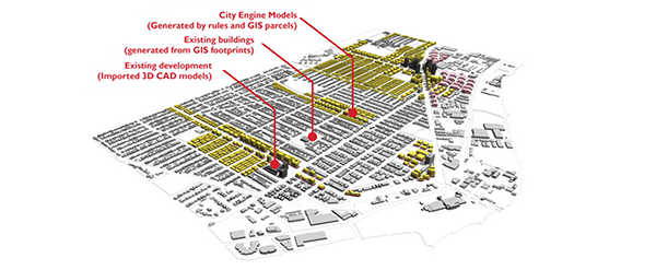
elementsdb+CityEngine This is an adaptation of elementsdb cases to CityEngine, the three-dimensional (3D) procedural modeling environment developed by ESRI. This prototype uses CityEngine’s parametric rule structure to automates the adaptation, replication and visualization of the geometric attributes of elementsdb cases to local site planning rules such as parcel size, orientation, building height, coverage and setbacks.
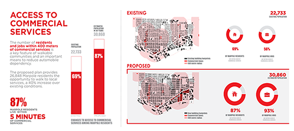
Measured Visualizations for Marpole elementslab provided workshops and urban design metrics and visualizations of contemplated land use planning in support of the ongoing Marpole Community Plan. The work elevates understandings of the city’s land use proposals for staff, city council, and community stakeholders. You can read more about this project here.
Kellett, R., Christen, A., Coops, N. C., van der Laan, M., Crawford, B. R., Tooke, T. R., Olchovski, I. (2013) “A systems approach to carbon cycling and emissions at an urban neighbourhood scale.” Landscape and Urban Planning, 110:43-58, 2013
Senbel, M., van der Laan, M., Kellett R., Girling, C., Stuart J. (2013) “Can form based code help reduce municipal GHG emissions in small towns? The case of Revelstoke, British Columbia.” Canadian Journal of Urban Research. (in press).
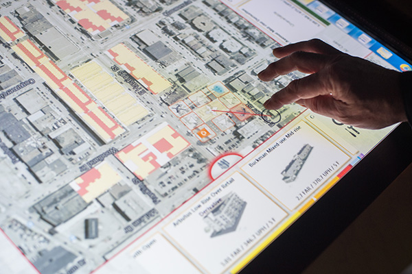
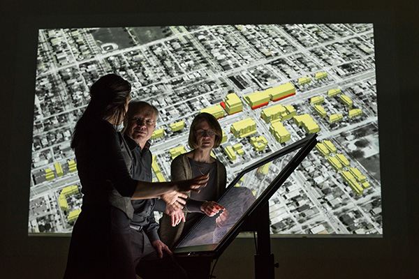
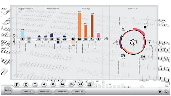
In recent years, tools and frameworks have become prominent components in the measurement of existing and future urban conditions, and tools that effectively educate the diverse group of stakeholders involved in planning will elevate the needed policy changes to align future development with emissions reductions goals. IDEASS has been exploring collaborative and visualization components for decision-support systems, researching the integration of multiple displays and the benefits of various form factors (multi-touch tabletop, large wall display, or personal hand-held display).
a multi-display interface for small group urban design collaboration
a related application of CityEngine, a parametric urban form modeling and analysis software
The CIRS decision theatre infrastructure (multiple displays, computer-controlled cameras and microphones, and a variety of handheld devices to support interaction) was used to test a number of scenarios using the proof-of-concept prototypes. IDEASS is examining the feasibility of using classroom “clickers” for large groups engaged in voting and preference solicitation activities.
[/column]
[column size=4]
Student Involvement
Co-Investigator Dr. Kellogg Booth has focused on collaboration technology, especially the role of shared multi-touch tabletop displays and large wall displays within the research. With MSc student Tao Su (who continues his involvement in the project after completing his degree) he participated in the development of the second-generation of a collaboration application for exploring urban plans that runs on a variety of tabletop architectures and which provides support for custom-built “widgets” that compute metrics based on the designs and display them in meaningful ways on the tabletop and also on auxiliary wall displays.
Summer BSc student Muhammad Yasir Dewji extended the capabilities of the widgets working with research associate Michael van der Laan. He and Ronald Kellett worked with a team of master’s students from the Masters of Digital Media program who developed a simulation that summarizes the goals of the research and illustrates some of the methodology that is being developed.
On-going work with MSc students Junhao Shi and Peter Beshai is examining the use of “clickers” (classroom personal response devices) to engage large groups of stakeholders in decision making and exploration exercises.
Related Publications
Guenther, J., Sheldon, T., and Senbel, M. “Public Decision Making, Land-use design and Visualization tools”. Paper presented at annual Canadian Institute of Planners Conference in Banff, Alberta, October 2012.
van der Laan, M., Kellett R., Senbel, M., Girling, C., Su, T., Booth, K. (2013) A Collaborative Multi-touch, Multi-Display, Urban Futures Tool. Simulation in Architecture and Urban Design.
Ronald Kellett, Kellogg Booth, Narges Mahyar, “Collaboration Technology for Stakeholder Engagement in Urban Planning”, Information Technology and City Life Workshop, CSCW 2015, March 14-16, 2015.
Subsequent to our November 2012 workshop, IDEASS worked with a team of graduate students in a Masters of Multimedia Design program in the Centre for Digital Media in Vancouver to develop a multi-media simulation of the neighbourhood scenario. This full term effort by six students and a faculty supervisor resulted in an interactive and visually rich multi-media simulation of a neighbourhood scale planning and urban design process that explores four alternative future plans and allows the user to compare them according to sustainability metrics.
The simulation mimics a typical decision-making process for community partners.
[/column]
[column size=4] More about Team GO:
Team GO wass a six-person team of students with diverse backgrounds (architecture, industrial design, interactive art & technology, programming, and mechatronics) that collaborated over the course of a term from January 2013 – April 2013.
David Acuña
Aasem Alabdullatief
Isabelle Allès David Lin
Kareem Negm
Emil Stephansen
Learn more about the development process in the project blog.
Data, local or on the web, is more useful when combined with data from other sources. Co-investigator Dr. Rachel Pottinger has been leading an exploration on how to integrate data from the building scale (in ifcXML format) with data from campus and city level (in CityGML format). This has also involved needing to integrate some data stored in Geographical Information Systems (GIS) format.
Change in Schemas and Their Integration: Starting from the ARTIFACT data, Dr. Rachel Pottinger, Dr. Sheryl Staub-French, and student Michael Lawrence have been exploring how to handle changing data and schemas that must be coordinated. We are building from the example of having building designs and cost estimates; we assume that two sources need to be kept up to date with each other, but they have little coordination.
The problem abstracts as follows: given a schema I and a schema J, update J as I changes.
Updating J automatically would drastically increase efficiency whenever such coordination occurs.
Recently, we showed when it is more efficient to create a new instance of J instead of updating the existing J instance. This work sheds new light on existing view maintenance work by showing when updates are necessary or when the views should be recomputed from scratch. We also performed a case study where we applied our general techniques to the cost estimation domain. This work has been published:
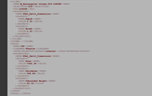
An example building design in XML consisting of a few columns and spaces.
During the early design stages of construction projects, accurate and timely cost feedback is critical to design decision making. This is particularly challenging for cost estimators, as they must quickly and accurately estimate the cost of the building when the design is still incomplete and evolving. State-of-the-art software tools typically use a rule-based approach to generate detailed quantities from the design details present in a building model and relate them to the cost items in a cost estimating database. In this paper, we propose a generic approach for creating and maintaining a cost estimate using flexible mappings between a building model and a cost estimate.
[/column]
[column size=4]
Student Involvement
Undergraduate Arianne Dee led the work on exploring which UBC campus data was stored in which source, particularly in understanding the campus’ GIS data.
MSc student Lan Wei created a mapping between the ifcXML format and CityGML representations along with creating a mediated schema so that the different sources can be queried simultaneously. This also shed light on how existing techniques to create mediated schemas fail to adequately create something that is both usable and comprehensible.
Undergraduate student Claire Edgcumbe worked on understanding the quality of ifcXML data and the issues that arise when the desired quality is not available.
MSc student Baipeng Han worked on how to extract the data from the campus GIS data so that it can be combined with the ifcXML and CityGML data.
MSc student Melsa Smith created a visualization of the schemas in order to make creating the mapping easier. MSc student Nayantara Duttachoudhury continued this work to help make it easier to visualize the data that is returned by queries.
MSc student Arni Thrastarson created the initial overview of a system for how to handle updates to cleansed data. MSc student Jessica Wong is extending that work to make an implemented system, which will require extending the theoretical work.
PhD student Michael Lawrence investigated the relationships between design and cost information and developed a novel approach using queries to create flexible mappings between design and cost views.
Application
The ifcXML, CityGML, and GIS data that we are integrating uses the UBC campus as a case study and we are now working with UBC Building Operations to apply this data set to operations and maintenance tasks.
The design and construction community has shown increasing interest in adopting building information models (BIMs). The richness of information provided by BIMs has the potential to streamline the design and construction processes by enabling enhanced communication, coordination, automation and analysis. The resulting models that are created during the design and construction phases are now being provided to owners as part of the handover sequence of as-built facility information. BIM is becoming a delivery requirement for an increasing number of owner operator institutional organisations for its potential to address many of the challenges related to project delivery and handover, and to support operations and maintenance (O&M) of the facility throughout its lifecycle. However, there are many challenges in extracting specific information at different stages of a building’s lifecycle and numerous issues remain such that traditional design and construction models need to be significantly reworked.
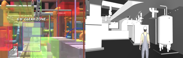
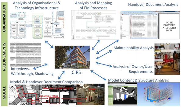
Different methods used in IDEASS research to analyse organisation, requirements and model.
Dr. Sheryl Staub-French has been leading explorations of BIM-based project delivery processes and BIM-enabled data integration and model management. Leading studies of several BIM projects from different organisational perspectives (owners and subcontractors) and within different project networks (complex design-build networks and mechanical systems supply chain), she works closely with Dr. Pottinger to better understand the data integration issues across project phases (from design through construction with an emphasis on design and cost information) and across project scales (from the building scale to the campus/city scale).
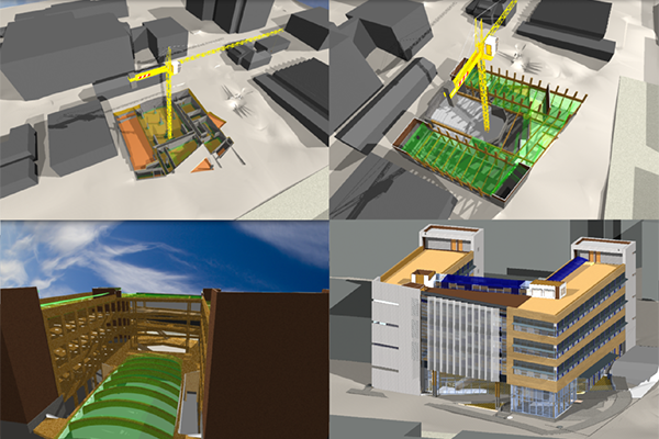
4D construction simulation model for the Centre for Interactive Research on Sustainability (CIRS) building, by Hasan Burak Cavka and Ngoc Tran.
[/column]
[column size=4]
Student Involvement
PhD student Hasan Cavka led the retrospective case study of CIRS that investigated the current building handover process and identified the potential implications for a BIM-based handover process, published in.
MASc student Raza Ali explored the potential use of BIM for building operations and energy use, which is also based on a case study of the CIRS project.
MASc student Helia Amiri led the investgiation of BIM-based tools to support cost estimating.
PhD student Erik Poirier investigated the factors that impact BIM- based project delivery processes and identified metrics that could be used to assess the impact of BIM from an organizational and project network perspective, aspects of which were published in a conference paper.
Working with Dr. Pottinger, post-Doc Madhav Nepal investigated how to extract construction information from a BIM, which was published in two journal papers.
[column size=8]
Decisions that impact building energy performance are made by many different decision making agents at different planning and design scales using different design tools and data, and can have dramatic consequences on the energy and emissions performance of the built environment. The planning and design of built environments can be improved using a process that encourages better integration and interaction between and among decision makers throughout the various scales and phases of urban planning, building design and building operation. The emerging field of Geodesign provides the foundation to address this need.
The Engage research project is analyzing and utilizing Geodesign approaches to advance the ways that digital technology enables design processes and tools to improve the practice of urban planning and building design for sustainability.
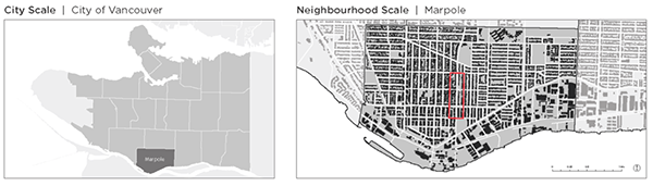
The project study area in the Marpole neighbourhood of Vancouver.
Specific objectives are focused on:
understanding the state of GIS and BIM in current urban design processes
determining future opportunities and barriers to GIS and BIM interoperability for supporting sustainable urban design
reveal how modifications to spatial and geometric detail relate to key considerations relevant to the Geodesign process and the assessment of energy efficiency
prototypes of process and technology innovation to enable faster, cheaper and more sustainable communities with more fully engaged decision-makers and residents
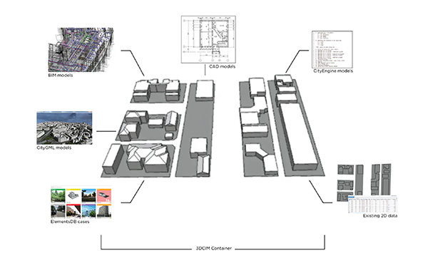
The CitySandbox concept, showing the various building representations that will be integrated.
Engage is an NSERC Strategic Project closely related to IDEASS.
[/column]
[column size=4]
Project Team
Sheryl Staub-French, Ron Kellett, Rachel Pottinger, Nicole Sylvia, Daniel Espinoza Ruiz, Maninder Singh, Jon Salter, Victor Ngo
Collaborators
Esri Canada has been providing enterprise geographic information system (GIS) solutions for over 30 years. Esri GIS solutions help businesses, governments and educational institutions worldwide to make timely and informed decisions by utilizing the power of spatial information and spatial analysis.
Esri Canada will be represented by Dr. Brent Hall, Director of Education and Research. Dr. Hall is an Adjunct Professor in the School of Planning at the University of Waterloo. He has over 30 years of academic research experience in spatial data acquisition and processing, including the development of 3D immersive urban models and their presentation in forms that facilitate group decision making. His research interests include use of Web 2.0 for spatial decision support and the use of mobile computing for 2 and 3D routing and way-finding in complex urban environments.