
Decisions that impact building energy performance are made by many different decision making agents at different planning and design scales using different design tools and data, and can have dramatic consequences on the energy and emissions performance of the built environment. The planning and design of built environments can be improved using a process that encourages better integration and interaction between and among decision makers throughout the various scales and phases of urban planning, building design and building operation. The emerging field of Geodesign provides the foundation to address this need.
The Engage research project is analyzing and utilizing Geodesign approaches to advance the ways that digital technology enables design processes and tools to improve the practice of urban planning and building design for sustainability.
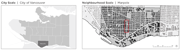
The project study area in the Marpole neighbourhood of Vancouver.
Specific objectives are focused on:
- understanding the state of GIS and BIM in current urban design processes
- determining future opportunities and barriers to GIS and BIM interoperability for supporting sustainable urban design
- reveal how modifications to spatial and geometric detail relate to key considerations relevant to the Geodesign process and the assessment of energy efficiency
- prototypes of process and technology innovation to enable faster, cheaper and more sustainable communities with more fully engaged decision-makers and residents
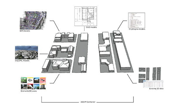
The CitySandbox concept, showing the various building representations that will be integrated.
Engage is an NSERC Strategic Project closely related to IDEASS.
Project Team
Sheryl Staub-French, Ron Kellett, Rachel Pottinger, Nicole Sylvia, Daniel Espinoza Ruiz, Maninder Singh, Jon Salter, Victor Ngo
Collaborators
Esri Canada has been providing enterprise geographic information system (GIS) solutions for over 30 years. Esri GIS solutions help businesses, governments and educational institutions worldwide to make timely and informed decisions by utilizing the power of spatial information and spatial analysis.
Esri Canada will be represented by Dr. Brent Hall, Director of Education and Research. Dr. Hall is an Adjunct Professor in the School of Planning at the University of Waterloo. He has over 30 years of academic research experience in spatial data acquisition and processing, including the development of 3D immersive urban models and their presentation in forms that facilitate group decision making. His research interests include use of Web 2.0 for spatial decision support and the use of mobile computing for 2 and 3D routing and way-finding in complex urban environments.